All documents
Environmental Assessment Guide
This guide provides a step-by-step process for carrying out environmental assessments at all stages of a project’s implementation. It also provides a checklist of important issues that need to be considered and factors in differences in the environmental laws and assessment procedures of Southern African countries where CRIDF is working. It is intended…
Year: 2017
Produced by: CRIDF
File size: 928 KB
Cubango-Okavango River Basin Homogeneous Units: Livelihoods Vulnerability Hotspot Mapping
This report captures the discussions of a Livelihoods Hotspot Mapping Stakeholder Inception Workshop which identified the distinct hazards and vulnerabilities of five distinct units within the Cubango-Okavango River Basin. The workshop was an initial step towards identifying potential technologies and interventions that development partners can…
Year: 2018
Produced by: CRIDF
File size: 2.15 MB
Zambezi River Basin Livelihood Response Programme: Consolidated Report on Revised Hotspot Narratives & Initial Project Repositories
CRIDF was requested by the Zambezi River Basin Commission to undertake a basin-wide vulnerability hotspot assessment as the basis for identifying priority areas of intervention. This document summarises the discussions of National Stakeholder Committees which were subsequently formed to review and analyse the hotspots – and identify vulnerabilities,…
Year: 2019
Produced by: CRIDF
File size: 1.76 MB
Climate Change Scenarios for the Limpopo River Basin
This document analyses projected annual climate changes within four domains of the Limpopo River Basin using self-organising maps (SOMs). Analysis suggests that temperatures will increase throughout the century. In all domains there are indications that annual rainfall distribution will become more spread, mainly through increases in the frequency…
Year: 2019
Produced by: CRIDF
File size: 17 MB
Climate Change Scenarios for the Orange Senqu River Basin
This document analyses projected climate changes within four domains of the Orange-Senqu River Basin using self-organising maps. Analysis suggests that temperatures will increase throughout the century in all domains. Within the two eastern domains annual rainfall distribution is expected to become more widespread, with increases in extended wetter…
Year: 2019
Produced by: CRIDF
File size: 15.8 MB
Update of the Save Basin Self-organising Maps Analysis
This update document complements an earlier report entitled ‘Southern Africa Climate Projections.’ It presents an assessment of extreme scenarios based on the original self-organising maps (soms); inter-annual variability statistics based on scenarios derived from soms analysis; and an assessment of adjustments under climate change in regions within…
Year: 2019
Produced by: CRIDF
File size: 3.55 MB
Self-organising Maps Results for the Upper Komati Domain
The Upper Komati Domain covers most of the upper parts of the basins within South Africa west of the border with Swaziland. This assessment provides an analysis of expected temperature and rainfall changes in the Upper Komati Domain using Self-Organised Maps (SOMs). An analysis is provided for each Representative Concentration Pathway (RCP) and each som…
Year: 2019
Produced by: CRIDF
File size: 1.52 MB
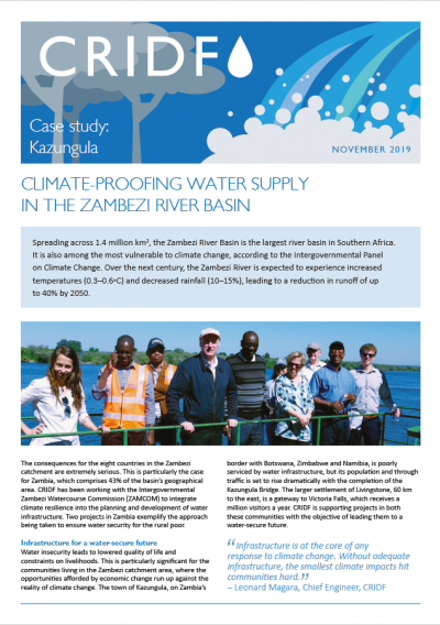
Climate-proofing Water Supply in the Zambezi River Basin
The Zambezi River Basin is projected to experience increasing temperatures and decreasing rainfall levels over the next century. This case study focuses on CRIDF efforts alongside the Intergovernmental Zambezi Watercourse Commission (ZAMCOM) to integrate climate resilience into the planning and development of water infrastructure. It draws upon…
Year: 2019
Produced by: CRIDF
File size: 866 KB
Gender and Irrigation: Briefing Note
Women play a central role in agriculture and food production in sub-Saharan Africa and make up approximately half of the region’s farmers. But people working on the development and implementation of agricultural projects tend to undervalue their role and their contributions to food security and income generation. This briefing note targets irrigation…
Year: 2019
Produced by: CRIDF
File size: 355KB
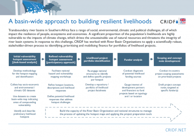
A Basin-Wide Approach to Building Resilient Livelihoods
Transboundary river basins in Southern Africa face a range of social, environmental, climatic and political challenges, all of which impact the resilience of people, ecosystems and economies. A significant proportion of the population’s livelihoods are highly vulnerable to the impacts of climate change, which drives the unsustainable use of…
Year: 2019
Produced by: CRIDF
File size: 1.6 MB